


La Thuile Seyssel

attitude73
User
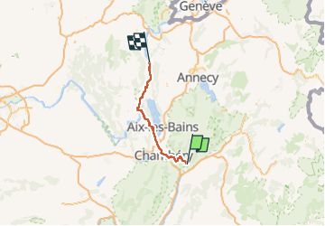

Length
85 km

Max alt
898 m

Uphill gradient
1262 m
Km-Effort
104 km

Min alt
227 m

Downhill gradient
1886 m
Boucle
No
Creation date :
2022-06-03 20:45:03.599
Updated on :
2022-06-03 21:28:06.322
0m
Difficulty : Very easy

FREE GPS app for hiking
 SityTrail
IGN / Geographical institutes
SityTrail Plus
The world is yours!
About
Trail Cycle of 85 km to be discovered at Auvergne-Rhône-Alpes, Savoy, La Thuile. This trail is proposed by attitude73.
Positioning
Country:
France
Region :
Auvergne-Rhône-Alpes
Department/Province :
Savoy
Municipality :
La Thuile
Location:
Unknown
Start:(Dec)
Start:(UTM)
270532 ; 5045875 (32T) N.
Comments